
Yellville topographic map
Interactive map
Click on the map to display elevation.
About this map
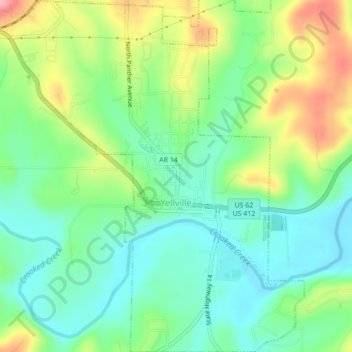
Name: Yellville topographic map, elevation, terrain.
Location: Yellville, Marion County, Arkansas, 72687, United States (36.21133 -92.70693 36.24631 -92.66905)
Average elevation: 211 m
Minimum elevation: 164 m
Maximum elevation: 298 m
Other topographic maps
Click on a map to view its topography, its elevation and its terrain.
Flippin
United States > Arkansas > Marion County
Flippin, Marion County, Arkansas, 72634, United States
Average elevation: 207 m
Peel
United States > Arkansas > Marion County
Peel, Marion County, Arkansas, 72668, United States
Average elevation: 244 m
Bull Shoals
United States > Arkansas > Marion County > Bull Shoals
Bull Shoals, Marion County, Arkansas, 72619, United States
Average elevation: 211 m
Pyatt
United States > Arkansas > Marion County > Pyatt
Pyatt, Marion County, Arkansas, 72672, United States
Average elevation: 260 m
Oakland
United States > Arkansas > Marion County
Oakland, Marion County, Arkansas, 72661, United States
Average elevation: 259 m
Bull Shoals
United States > Arkansas > Marion County
Bull Shoals, Marion County, Arkansas, 72619, United States
Average elevation: 211 m