
Thank you for supporting this site ❤️
Make a donation
Make a donation
Mercedes topographic map
Click on the map to display elevation.
Thank you for supporting this site ❤️
Make a donation
Make a donation
About this map
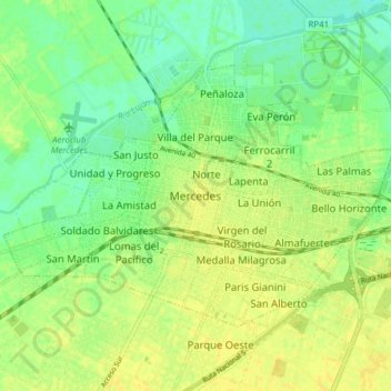
Name: Mercedes topographic map, elevation, terrain.
Location: Mercedes, Partido de Mercedes, Buenos Aires, Argentina (-34.69399 -59.48895 -34.62946 -59.39258)
Average elevation: 39 m
Minimum elevation: 29 m
Maximum elevation: 46 m
Thank you for supporting this site ❤️
Make a donation
Make a donation
Other topographic maps
Click on a map to view its topography, its elevation and its terrain.
Thank you for supporting this site ❤️
Make a donation
Make a donation
Thank you for supporting this site ❤️
Make a donation
Make a donation
General San Martín
Argentina > Buenos Aires > General San Martín > General San Martín
Average elevation: 25 m
Thank you for supporting this site ❤️
Make a donation
Make a donation