
Thank you for supporting this site ❤️
Make a donation
Make a donation
Hamilton topographic map
Click on the map to display elevation.
Thank you for supporting this site ❤️
Make a donation
Make a donation
About this map
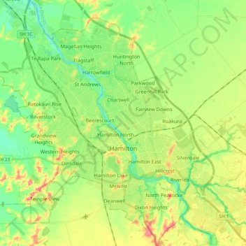
Name: Hamilton topographic map, elevation, terrain.
Location: Hamilton, Waikato, New Zealand (-37.84604 175.18430 -37.69933 175.34488)
Average elevation: 42 m
Minimum elevation: 11 m
Maximum elevation: 89 m
Thank you for supporting this site ❤️
Make a donation
Make a donation
Other topographic maps
Click on a map to view its topography, its elevation and its terrain.