
Thank you for supporting this site ❤️
Make a donation
Make a donation
Budhanilkantha topographic map
Click on the map to display elevation.
Thank you for supporting this site ❤️
Make a donation
Make a donation
About this map
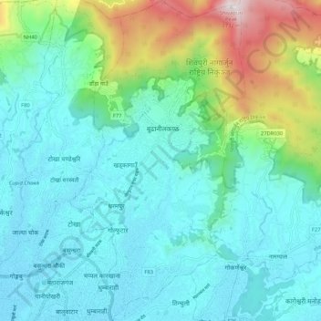
Name: Budhanilkantha topographic map, elevation, terrain.
Location: Budhanilkantha, Kathmandu, Bagmati Pradesh, Nepal (27.72655 85.33186 27.81413 85.38894)
Average elevation: 1,604 m
Minimum elevation: 1,301 m
Maximum elevation: 2,701 m
Thank you for supporting this site ❤️
Make a donation
Make a donation
Other topographic maps
Click on a map to view its topography, its elevation and its terrain.