
Thank you for supporting this site ❤️
Make a donation
Make a donation
Zell am Main topographic map
Click on the map to display elevation.
Thank you for supporting this site ❤️
Make a donation
Make a donation
About this map
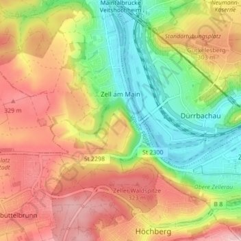
Name: Zell am Main topographic map, elevation, terrain.
Location: Zell am Main, Landkreis Würzburg, Bavaria, 97299, Germany (49.78199 9.82617 49.82646 9.88348)
Average elevation: 262 m
Minimum elevation: 166 m
Maximum elevation: 355 m
Thank you for supporting this site ❤️
Make a donation
Make a donation
Other topographic maps
Click on a map to view its topography, its elevation and its terrain.