
Thank you for supporting this site ❤️
Make a donation
Make a donation
Salta topographic map
Click on the map to display elevation.
Thank you for supporting this site ❤️
Make a donation
Make a donation
Salta
Although Salta Province is located near the Tropic of Capricorn, it has a wide range of climates due to variation in altitude and the influence of orography. The orientation of the Andes influences the distribution of precipitation within the province.
Thank you for supporting this site ❤️
Make a donation
Make a donation
About this map
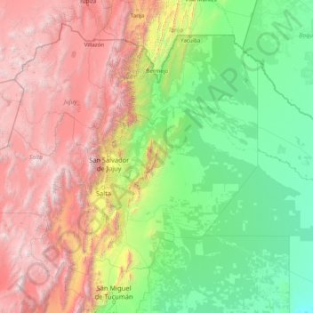
Name: Salta topographic map, elevation, terrain.
Location: Salta, Argentina (-26.41670 -68.56789 -21.99877 -62.33923)
Average elevation: 1,630 m
Minimum elevation: 104 m
Maximum elevation: 6,196 m
Thank you for supporting this site ❤️
Make a donation
Make a donation
Other topographic maps
Click on a map to view its topography, its elevation and its terrain.