
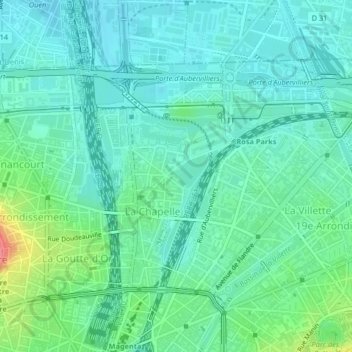
La Chapelle topographic map
Interactive map
Click on the map to display elevation.
About this map
Name: La Chapelle topographic map, elevation, terrain.
Average elevation: 55 m
Minimum elevation: 37 m
Maximum elevation: 116 m
Other topographic maps
Click on a map to view its topography, its elevation and its terrain.
18th Arrondissement
France > Ile-de-France > Paris
18th Arrondissement, Paris, Ile-de-France, Metropolitan France, 75018, France
Average elevation: 59 m
Paris
France > Ile-de-France > Paris
Paris, Ile-de-France, Metropolitan France, France
Average elevation: 62 m
Salpêtrière
France > Ile-de-France > Paris
Salpêtrière, 13th Arrondissement, Paris, Ile-de-France, Metropolitan France, 75013, France
Average elevation: 47 m
Quartier du Faubourg-du-Roule
France > Ile-de-France > Paris
Quartier du Faubourg-du-Roule, 8th Arrondissement of Paris, Paris, Ile-de-France, Metropolitan France, 75008, France
Average elevation: 53 m