
Make a donation
Distrito Ciudad de Luján de Cuyo topographic map
Click on the map to display elevation.
Make a donation
Distrito Ciudad de Luján de Cuyo
Situated in the upper Mendoza valley, where the river is half-way through its journey from the Andes mountains to the eastern plains, many Lujan de Cuyo vineyards sit at altitudes of around 1000 m (3280 ft). Malbec in particular is successful in Lujan de Cuyo, but the appellation also produces good Cabernet Sauvignon, Chardonnay and Torrontes. The majority of the vineyards are on alluvial soils; sandy or stony surfaces on clay substrata.
Make a donation
About this map
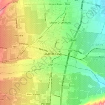
Name: Distrito Ciudad de Luján de Cuyo topographic map, elevation, terrain.
Average elevation: 949 m
Minimum elevation: 888 m
Maximum elevation: 1,033 m
Make a donation
Other topographic maps
Click on a map to view its topography, its elevation and its terrain.
Puente del Inca
Argentina > Mendoza > Departamento Luján de Cuyo > Puente del Inca
Situated at 2,744 m (9,003 ft) above sea level, Puente del Inca has a warm-summer mediterranean continental climate (Dsb, according to the Köppen climate classification), as at least 4 months see an average temperature above 10 °C (50 °F) and at least one month sees an average temperature below 0 °C (32…
Average elevation: 3,006 m