
Make a donation
Seville topographic map
Click on the map to display elevation.
Make a donation
Seville
Seville has an area of 141 km2 (54 sq mi), according to the National Topographic Map (Mapa Topográfico Nacional) series from the Instituto Geográfico Nacional – Centro Nacional de Información Geográfica, the country's civilian survey organisation (pages 984, 985 and 1002). The city is situated in the fertile valley of the River Guadalquivir. The average height above sea level is 7 metres (23 feet). Most of the city is on the east side of the river, while Triana, La Cartuja and Los Remedios are on the west side. The Aljarafe region lies further west, and is considered part of the metropolitan area. The city has boundaries on the north with La Rinconada, La Algaba and Santiponce; on the east with Alcalá de Guadaira; on the south with Dos Hermanas and Gelves and on the west with San Juan de Aznalfarache, Tomares and Camas.
Make a donation
About this map
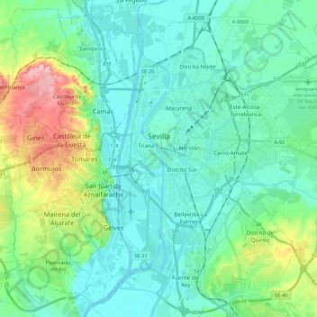
Name: Seville topographic map, elevation, terrain.
Location: Seville, Sevilla, Andalusia, Spain (37.30020 -6.03292 37.45296 -5.81916)
Average elevation: 35 m
Minimum elevation: -2 m
Maximum elevation: 164 m
Make a donation
Other topographic maps
Click on a map to view its topography, its elevation and its terrain.
Alhambra
Spain > Andalusia > Comarca de la Vega de Granada > Granada
During the reign of the Nasrid Dynasty, the Alhambra was transformed into a palatine city, complete with an irrigation system composed of aqueducts and water channels that provided water for the complex and for other nearby countryside palaces such as the Generalife. Previously, the old fortresses on the hill…
Average elevation: 759 m