
Thank you for supporting this site ❤️
Make a donation
Make a donation
Gunung Angsi topographic map
Click on the map to display elevation.
Thank you for supporting this site ❤️
Make a donation
Make a donation
Gunung Angsi
Mount Angsi (Malay: Gunung Angsi) is a mountain which is located between the border between Ulu Bendul, Kuala Pilah District and Senawang, Seremban District in Negeri Sembilan, Malaysia. Part of the Titiwangsa Mountains, it is the seventh tallest mountain in the state, behind Mts. Besar Hantu, Hantu Kecil, Telapak Buruk, Berembun and Datuk, with an elevation of 2,707 feet (825 m).
Thank you for supporting this site ❤️
Make a donation
Make a donation
About this map
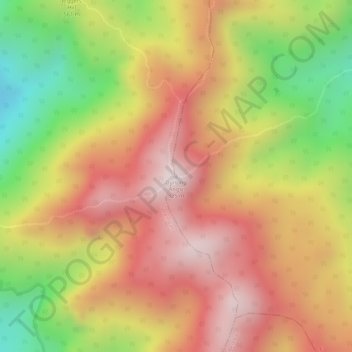
Name: Gunung Angsi topographic map, elevation, terrain.
Location: Gunung Angsi, Kuala Pilah, Negeri Sembilan, Malaysia (2.69854 102.04800 2.69864 102.04810)
Average elevation: 552 m
Minimum elevation: 190 m
Maximum elevation: 803 m
Thank you for supporting this site ❤️
Make a donation
Make a donation