
Thank you for supporting this site ❤️
Make a donation
Make a donation
Tuchenbach topographic map
Click on the map to display elevation.
Thank you for supporting this site ❤️
Make a donation
Make a donation
Tuchenbach
Tuchenbach is located about 20 Kilometer west of Nuremberg. The closest villages are Obermichelbach, Veitsbronn, Puschendorf and the town of Herzogenaurach. The altitude is 345 Meters. The area of Tuchenbach is 6.50 km2
Thank you for supporting this site ❤️
Make a donation
Make a donation
About this map
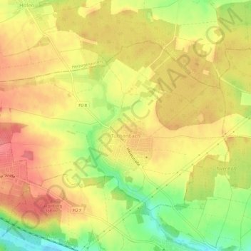
Name: Tuchenbach topographic map, elevation, terrain.
Average elevation: 348 m
Minimum elevation: 303 m
Maximum elevation: 377 m
Thank you for supporting this site ❤️
Make a donation
Make a donation
Other topographic maps
Click on a map to view its topography, its elevation and its terrain.