
Ottawa topographic map
Click on the map to display elevation.
Ottawa
Ottawa, the capital city of Canada, is situated on the south bank of the Ottawa River at the confluence with the Rideau River. The city's topography is characterized by gently rolling terrain with elevations ranging from approximately 44 meters (144 feet) above sea level at the Ottawa River to its highest point of 166 meters (545 feet), located 2.6 kilometers (1.62 miles) south-southeast of Manion Corners. The landscape is predominantly composed of Paleozoic carbonate and shale lowlands, surrounded by more rugged Precambrian igneous and metamorphic formations. Notably, the nearby Gatineau Hills, part of the southern tip of the Canadian Shield, rise across the Ottawa River in Quebec, providing a contrasting hilly backdrop to the otherwise moderate relief of the Ottawa Valley.
About this map
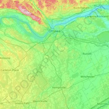
Name: Ottawa topographic map, elevation, terrain.
Location: Ottawa, Eastern Ontario, Ontario, Canada (44.96177 -76.35559 45.53765 -75.24658)
Average elevation: 105 m
Minimum elevation: 38 m
Maximum elevation: 409 m
Other topographic maps
Click on a map to view its topography, its elevation and its terrain.
Sesekinika
Canada > Ontario > Timiskaming District > Unorganized West Timiskaming
Average elevation: 320 m
London
London has a humid continental climate (Köppen Dfb), though due to its downwind location relative to Lake Huron and elevation changes across the city, it is virtually on the Dfa/Dfb (hot summer) boundary favouring the former climate zone to the southwest of the confluence of the South and North Thames Rivers,…
Average elevation: 269 m