
South Cotabato topographic map
Interactive map
Click on the map to display elevation.
About this map
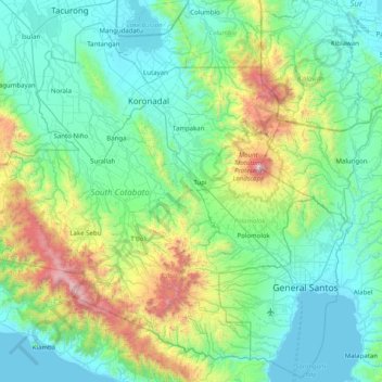
Name: South Cotabato topographic map, elevation, terrain.
Location: South Cotabato, Soccsksargen, Philippines (5.92838 124.24390 6.66302 125.27648)
Average elevation: 356 m
Minimum elevation: -4 m
Maximum elevation: 2,241 m
Other topographic maps
Click on a map to view its topography, its elevation and its terrain.
General Santos
Philippines > South Cotabato > General Santos
General Santos, South Cotabato, Soccsksargen, 9500, Philippines
Average elevation: 149 m