
Matjhabeng Local Municipality topographic map
Interactive map
Click on the map to display elevation.
About this map
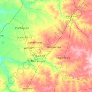
Name: Matjhabeng Local Municipality topographic map, elevation, terrain.
Average elevation: 1,376 m
Minimum elevation: 1,257 m
Maximum elevation: 1,579 m
Other topographic maps
Click on a map to view its topography, its elevation and its terrain.
Matjhabeng Ward 32
RSA > Free State > Matjhabeng Local Municipality
Matjhabeng Ward 32, Matjhabeng Local Municipality, Lejweleputswa District Municipality, Free State, RSA
Average elevation: 1,358 m