
Vũng Tàu topographic map
Interactive map
Click on the map to display elevation.
About this map
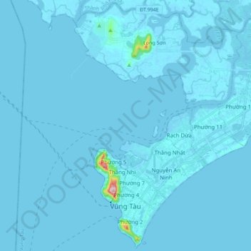
Name: Vũng Tàu topographic map, elevation, terrain.
Location: Vũng Tàu, Bà Rịa - Vũng Tàu Province, Vietnam (10.32030 107.04181 10.48418 107.21176)
Average elevation: 3 m
Minimum elevation: -9 m
Maximum elevation: 245 m
Other topographic maps
Click on a map to view its topography, its elevation and its terrain.
Mỹ Thuận
Vietnam > Bà Rịa - Vũng Tàu Province > Long Dat District > Phuoc Hai Township
Average elevation: 10 m
Thi Vai River
Vietnam > Bà Rịa - Vũng Tàu Province > Long Thành District > Phú Mỹ
Average elevation: 10 m
Núi Nứa
Vietnam > Bà Rịa - Vũng Tàu Province > Chau Duc District > Xuan Son Commune
Average elevation: 78 m
Tân Thành
Vietnam > Bà Rịa - Vũng Tàu Province > Chau Duc District > Quang Thanh Commune
Average elevation: 135 m