
Vermont topographic map
Interactive map
Click on the map to display elevation.
About this map
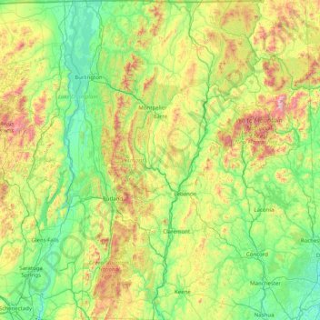
Name: Vermont topographic map, elevation, terrain.
Location: Vermont, USA (42.72696 -73.43774 45.01667 -71.46539)
Average elevation: 348 m
Minimum elevation: -2 m
Maximum elevation: 1,893 m
Other topographic maps
Click on a map to view its topography, its elevation and its terrain.
Montpelier
USA > Vermont > Montpelier
Montpelier, Washington County, Vermont, 05602, USA
Average elevation: 284 m