
Make a donation
Calingasta topographic map
Click on the map to display elevation.
Make a donation
Calingasta
Calingasta has a rugged, mountainous topography due to its location at the foot of the Andes. Mount Mercedario is the eighth-highest mountain of the Andes with an altitude of 6,720 metres (22,050 ft). It is located 100 kilometres (62 mi) north of Aconcagua. The precordillera range is the Sierra del Tontal, separating the region from the arid plains to the east. The soil is mainly desert with little vegetation cover except on the river banks in the valleys.
Make a donation
About this map
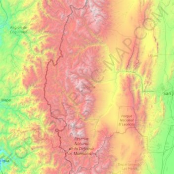
Name: Calingasta topographic map, elevation, terrain.
Location: Calingasta, San Juan, Argentina (-32.62663 -70.56968 -30.26862 -69.10017)
Average elevation: 2,393 m
Minimum elevation: 74 m
Maximum elevation: 6,583 m
Make a donation
Other topographic maps
Click on a map to view its topography, its elevation and its terrain.
San Juan
San Juan is ranked second among the wine-producing provinces of Argentina. It has a cultivated area of 116,700 acres at altitudes of between 1,970 (601m) and 4,590 feet (1399m) above sea level. This region specializes in Syrah, Malbec, Cabernet Sauvignon, Bonarda, Chardonnay and Torrontés. Because of this…
Average elevation: 694 m
Make a donation
Make a donation
Make a donation