
Rangamati Hill District topographic map
Interactive map
Click on the map to display elevation.
About this map
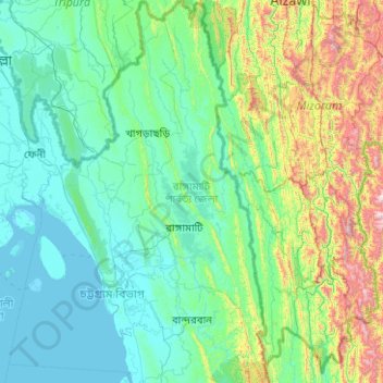
Name: Rangamati Hill District topographic map, elevation, terrain.
Location: Rangamati Hill District, Chattogram Division, 4500, Bangladesh (21.89270 91.93252 23.74237 92.62032)
Average elevation: 276 m
Minimum elevation: -1 m
Maximum elevation: 2,188 m
Other topographic maps
Click on a map to view its topography, its elevation and its terrain.
Ukhia
Bangladesh > Chattogram Division > Cox's Bazar District > Ukhia
Ukhia, Cox's Bazar District, Chattogram Division, 4750, Bangladesh
Average elevation: 18 m
Kaptai Lake
Bangladesh > Chattogram Division
Kaptai Lake, Rangamati Hill District, Chattogram Division, Bangladesh
Average elevation: 102 m
Chattogram
Bangladesh > Chattogram Division > Chattogram
Chattogram, Chattogram District, Chattogram Division, 4000, Bangladesh
Average elevation: 6 m