Geolocate

Pembrokeshire topographic map

Click on the map to display elevation.

About this map

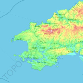
Name: Pembrokeshire topographic map, elevation, terrain.

Location: Pembrokeshire, Wales, United Kingdom (51.59592 -5.67030 52.11804 -4.48559)

Average elevation: 43 m

Minimum elevation: 0 m

Maximum elevation: 522 m

Other topographic maps

Click on a map to view its topography, its elevation and its terrain.

Llandudno

United Kingdom > Wales > Conwy

Average elevation: 19 m

Cardiff

United Kingdom > Wales > Cardiff

Average elevation: 55 m

Newport

United Kingdom > Wales > Newport

Average elevation: 89 m

Snowdon

United Kingdom > Wales > Gwynedd

Snowdon (/ˈsnoʊdən/) or Yr Wyddfa (pronounced [ər ˈʊɨ̞̯ðva] (listen)), is the highest mountain in Wales, at an elevation of 1,085 metres (3,560 ft) above sea level, and the highest point in the British Isles outside the Scottish Highlands. It is located in Snowdonia National Park (Parc Cenedlaethol…

Average elevation: 692 m

Abergavenny

United Kingdom > Wales > Monmouthshire

Average elevation: 187 m

Llanelli

United Kingdom > Wales > Carmarthenshire

Average elevation: 41 m

Pontarddulais

United Kingdom > Wales > Swansea

Average elevation: 82 m

Swansea

United Kingdom > Wales > Swansea

Much of Swansea is hilly with the main area of upland being located in the council ward of Mawr. Areas up to 185 metres (607 ft) in elevation range across the central section: Kilvey Hill, Townhill and Llwynmawr separate the centre of Swansea from its northern suburbs. Cefn Bryn, a ridge of high land, is the…

Average elevation: 73 m

Wrexham

United Kingdom > Wales > Wrexham

Average elevation: 139 m

Rhayader

United Kingdom > Wales > Powys

Average elevation: 305 m

Aberystwyth

United Kingdom > Wales > Ceredigion

Aberystwyth experiences an oceanic climate (Köppen climate classification Cfb) similar to almost all of the United Kingdom. This is particularly pronounced due to its west coast location facing the Irish Sea. Air undergoes little land moderation and so temperatures closely reflect the sea temperature when…

Average elevation: 39 m

Ruthin

United Kingdom > Wales > Denbighshire

The Myddleton Arms is also known as the Seven Eyes. It is said to have been built in the 14th century. The Dutch style design, long, steeped roof is attributed to Sir Richard Clough, an Elizabethan merchant. It has four tiers of dormer windows, each at a different elevation, known locally as the seven eyes of…

Average elevation: 162 m

Pwllheli

United Kingdom > Wales > Gwynedd

Average elevation: 22 m

Laugharne

United Kingdom > Wales > Carmarthenshire

Average elevation: 38 m

Ogmore

United Kingdom > Wales > Vale of Glamorgan

Average elevation: 47 m

Cwmbran

United Kingdom > Wales > Torfaen

Average elevation: 88 m

Caban-Coch Dam

United Kingdom > Wales > Powys > Elan Village

Average elevation: 336 m

Bancycapel

United Kingdom > Wales > Carmarthenshire > Idole

Average elevation: 99 m

Penrhos

United Kingdom > Wales > Powys > Sarnau

Average elevation: 106 m

Dylife

United Kingdom > Wales > Powys

Average elevation: 396 m

Talgarth

United Kingdom > Wales > Powys

Average elevation: 174 m

Pontypridd

United Kingdom > Wales > Pontypridd

Average elevation: 184 m

Foel Penolau

United Kingdom > Wales

Average elevation: 423 m

Ysgafell Wen

United Kingdom > Wales

Average elevation: 517 m

Moel Yr Hydd

United Kingdom > Wales

Average elevation: 429 m

Taff

United Kingdom > Wales

Average elevation: 270 m

Fron Goch

United Kingdom > Wales

Average elevation: 196 m

Yr Eifl

United Kingdom > Wales

Average elevation: 257 m

Mynydd Carningli

United Kingdom > Wales

Average elevation: 213 m

Dudwell Mountain

United Kingdom > Wales

Average elevation: 118 m

Penhros Coppice

United Kingdom > Wales

Average elevation: 107 m

Cefn Coch

United Kingdom > Wales

Average elevation: 328 m

Cefn Coch

United Kingdom > Wales

Average elevation: 458 m

Gwynedd

United Kingdom > Wales

Average elevation: 332 m

Powys

United Kingdom > Wales

Average elevation: 285 m

Isle of Anglesey

United Kingdom > Wales

Average elevation: 65 m

Bullwell Bay

United Kingdom > Wales

Average elevation: 14 m

Coed Maes-gwyn

United Kingdom > Wales > Gwynedd > Llanuwchllyn

Average elevation: 224 m

Tremadog Bay

United Kingdom > Wales

Average elevation: 0 m

Bangor

United Kingdom > Wales > Bangor

Average elevation: 149 m

Builth Wells

United Kingdom > Wales > Powys

Average elevation: 232 m

Welshpool

United Kingdom > Wales > Powys

The Mermaid Inn, 28 High Street, was very probably an early 16th-century merchant's house, placed on a burgage plot between the High Street and Alfred Jones Court. The timber-framed building has long storehouse or wing to the rear. The frontage was remodelled c. 1890, by Frank H. Shayler, architect, of…

Average elevation: 156 m

Ystradgynlais

United Kingdom > Wales > Powys

Average elevation: 202 m

Capel Curig

United Kingdom > Wales > Conwy

Average elevation: 299 m

Bala Lake

United Kingdom > Wales > Gwynedd > Llangywer

Average elevation: 246 m

River Taff

United Kingdom > Wales > Cardiff > Cardiff

Average elevation: 20 m

Clyro

United Kingdom > Wales > Powys

Average elevation: 152 m

Llanyre

United Kingdom > Wales > Powys

Average elevation: 238 m

Golygfa Llyn Clywedog

United Kingdom > Wales > Powys

Average elevation: 337 m

Snead

United Kingdom > Wales > Powys

Average elevation: 205 m

Bleddfa

United Kingdom > Wales > Powys

Average elevation: 340 m

Pontrobert

United Kingdom > Wales > Powys

Average elevation: 174 m

Penybanc

United Kingdom > Wales > Carmarthenshire

Average elevation: 69 m

Morfa Harlech

United Kingdom > Wales > Gwynedd > Harlech

Average elevation: 2 m

Craig Cerrig-gleisiad

United Kingdom > Wales > Powys

Average elevation: 495 m

Bwlch-y-ffridd

United Kingdom > Wales > Powys

Average elevation: 229 m

Broad Haven

United Kingdom > Wales > Pembrokeshire

Average elevation: 41 m

River Severn

United Kingdom > Wales > Powys > Welshpool

The River Severn (Welsh: Afon Hafren, pronounced [ˈavɔn ˈhavrɛn]), at 220 miles (354 km) long, is the longest river in Great Britain. It is also the river with the most voluminous flow of water by far in all of England and Wales, with an average flow rate of 107 m3/s (3,800 cu ft/s) at Apperley,…

Average elevation: 92 m

Gwernaffield

United Kingdom > Wales > Flintshire

Average elevation: 192 m

Tonypandy

United Kingdom > Wales > Rhondda Cynon Taf

Average elevation: 285 m

Llechwedd

United Kingdom > Wales > Conwy

Average elevation: 366 m

Skewen

United Kingdom > Wales > Neath Port Talbot

Average elevation: 57 m

Llanover

United Kingdom > Wales > Monmouthshire

Average elevation: 117 m

Llanon

United Kingdom > Wales > Ceredigion

Average elevation: 60 m

Mathern

United Kingdom > Wales > Monmouthshire

Average elevation: 27 m

Pontardawe

United Kingdom > Wales > Neath Port Talbot

Average elevation: 161 m

Trawsfynydd

United Kingdom > Wales > Gwynedd

Average elevation: 234 m

Caerleon

United Kingdom > Wales > Gwent > Newport > Caerleon

Average elevation: 37 m

Brecon

United Kingdom > Wales > Powys

Average elevation: 216 m

Crickhowell

United Kingdom > Wales > Powys

Average elevation: 253 m

Llandrindod Wells

United Kingdom > Wales > Powys

Average elevation: 247 m

Llanddewi

United Kingdom > Wales > Swansea

Average elevation: 63 m

Banc Y Garth

United Kingdom > Wales > Carmarthenshire

Average elevation: 342 m

Ton-Mawr

United Kingdom > Wales > Neath Port Talbot

Average elevation: 222 m

Beulah

United Kingdom > Wales > Powys

Average elevation: 239 m

Beulah

United Kingdom > Wales > Ceredigion

Average elevation: 139 m

Colwyn Bay

United Kingdom > Wales > Conwy

Average elevation: 68 m

Grosmont

United Kingdom > Wales > Monmouthshire

Average elevation: 128 m

New Brighton

United Kingdom > Wales > Flintshire

Average elevation: 131 m

Bethlehem

United Kingdom > Wales > Carmarthenshire

Average elevation: 115 m

Murton

United Kingdom > Wales > Swansea

Average elevation: 66 m

Abermorddu

United Kingdom > Wales > Flintshire

Average elevation: 124 m

Abergynolwyn

United Kingdom > Wales > Gwynedd

Average elevation: 187 m

Brynithel

United Kingdom > Wales > Blaenau Gwent

Average elevation: 288 m

Rhosgoch

United Kingdom > Wales > Powys

Average elevation: 311 m

Rhinog Fawr

United Kingdom > Wales > Gwynedd

Average elevation: 434 m

Llangattock

United Kingdom > Wales > Powys

Average elevation: 166 m

Llanfilo

United Kingdom > Wales > Powys

Average elevation: 187 m

Oxwich

United Kingdom > Wales > Swansea

Average elevation: 36 m

Nicholaston

United Kingdom > Wales > Swansea

Average elevation: 53 m

Abersychan

United Kingdom > Wales > Torfaen

Average elevation: 299 m

Penpedairheol

United Kingdom > Wales > Monmouthshire > Monkswood

Average elevation: 74 m

Ynystawe

United Kingdom > Wales > Swansea

Average elevation: 63 m

Ynysmeudwy

United Kingdom > Wales > Neath Port Talbot

Average elevation: 126 m