
Turkmenbashy topographic map
Interactive map
Click on the map to display elevation.
Turkmenbashy
Türkmenbaşy (Turkmen Cyrillic: Түркменбашы, Turkmen Arabic; توركمنباشی, also spelled Turkmenbashy and Turkmenbashi, the latter a back-formation of the Cyrillic Түркменбаши), formerly known as Krasnovodsk (Russian: Красноводск), Kyzyl-Su, and Shagadam (Turkmen: Şagadam), is a city in Balkan Province in Turkmenistan, on the Türkmenbaşy Gulf of the Caspian Sea. It sits at an elevation of 27 metres (89 feet). The population (est 2004) was 86,800, mostly ethnic Turkmens but also Russian, Armenian and Azeri minorities. As the terminus of the Trans-Caspian Railway and site of a major seaport on the Caspian, it is an important transportation center. The city is also the site of Turkmenistan's largest oil refining complex.
About this map
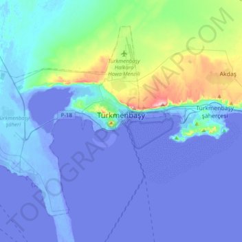
Name: Turkmenbashy topographic map, elevation, terrain.
Location: Turkmenbashy, Balkan Region, Turkmenistan (39.90678 52.76741 40.09207 53.07525)
Average elevation: 16 m
Minimum elevation: -29 m
Maximum elevation: 249 m
Other topographic maps
Click on a map to view its topography, its elevation and its terrain.