
Gdańsk topographic map
Interactive map
Click on the map to display elevation.
About this map
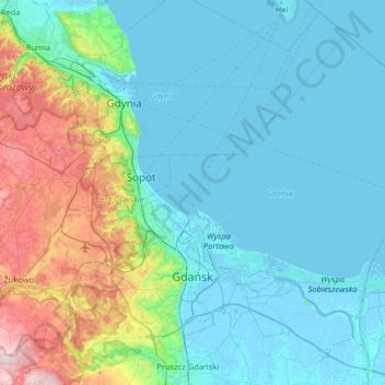
Name: Gdańsk topographic map, elevation, terrain.
Location: Gdańsk, Pomeranian Voivodeship, Poland (54.27492 18.42950 54.58273 19.07030)
Average elevation: 43 m
Minimum elevation: -5 m
Maximum elevation: 241 m
Other topographic maps
Click on a map to view its topography, its elevation and its terrain.