
Kemaman District topographic map
Interactive map
Click on the map to display elevation.
About this map
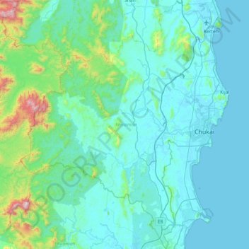
Name: Kemaman District topographic map, elevation, terrain.
Location: Kemaman District, Terengganu, Malaysia (3.88135 102.89147 4.59792 103.49232)
Average elevation: 145 m
Minimum elevation: -2 m
Maximum elevation: 1,446 m
Other topographic maps
Click on a map to view its topography, its elevation and its terrain.
Kenyir Dam
Kenyir Dam, Hulu Terennganu, Terengganu, Malaysia
Average elevation: 215 m