
Thank you for supporting this site ❤️
Make a donation
Make a donation
Tonglu County topographic map
Click on the map to display elevation.
Thank you for supporting this site ❤️
Make a donation
Make a donation
About this map
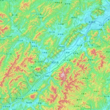
Name: Tonglu County topographic map, elevation, terrain.
Location: Tonglu County, Hangzhou City, Zhejiang, 311500, China (29.59165 119.17525 30.09067 119.97044)
Average elevation: 255 m
Minimum elevation: 2 m
Maximum elevation: 1,226 m
Thank you for supporting this site ❤️
Make a donation
Make a donation
Other topographic maps
Click on a map to view its topography, its elevation and its terrain.