
Thank you for supporting this site ❤️
Make a donation
Make a donation
Goiânia topographic map
Click on the map to display elevation.
Thank you for supporting this site ❤️
Make a donation
Make a donation
Goiânia
The "cerrado" landscape is characterized by extensive savanna formations crossed by gallery forests and stream valleys and includes various types of vegetation. Humid fields and "buriti" palm paths are found where the water table is near the surface. Alpine pastures occur at higher altitudes and mesophytic forests on more fertile soils.
Thank you for supporting this site ❤️
Make a donation
Make a donation
About this map
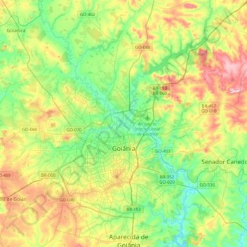
Name: Goiânia topographic map, elevation, terrain.
Average elevation: 795 m
Minimum elevation: 663 m
Maximum elevation: 1,039 m
Thank you for supporting this site ❤️
Make a donation
Make a donation