
Ituaçu topographic map
Interactive map
Click on the map to display elevation.
About this map
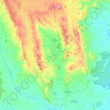
Name: Ituaçu topographic map, elevation, terrain.
Average elevation: 632 m
Minimum elevation: 300 m
Maximum elevation: 1,547 m
Other topographic maps
Click on a map to view its topography, its elevation and its terrain.
Chapada Diamantina
The Chapada Diamantina lies at the center of Bahia State and forms the northern part of the Espinhaço Mountain Range. The region is approximately 38,000 km2 (15,000 sq mi) in area and encompasses 58 municipalities. Technically, this region is considered a part of the caatinga biome, and contains some of its…
Average elevation: 1,390 m