
Thank you for supporting this site ❤️
Make a donation
Make a donation
Crimean Peninsula topographic map
Click on the map to display elevation.
Thank you for supporting this site ❤️
Make a donation
Make a donation
Crimean Peninsula
The main range of these mountains rises with extraordinary abruptness from the deep floor of the Black Sea to an altitude of 600–1,545 metres (1,969–5,069 ft), beginning at the southwest point of the peninsula, called Cape Fiolent. Some Greek myths state that this cape was supposedly crowned with the temple of Artemis where Iphigeneia officiated as priestess. Uchan-su, on the south slope of the mountains, is the highest waterfall in Crimea.
Thank you for supporting this site ❤️
Make a donation
Make a donation
About this map
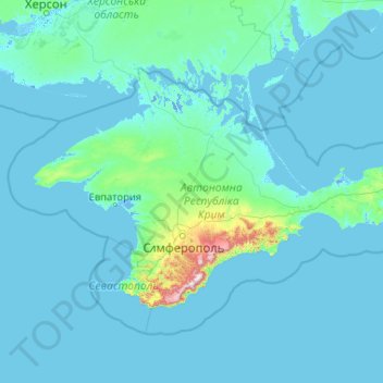
Name: Crimean Peninsula topographic map, elevation, terrain.
Average elevation: 35 m
Minimum elevation: -5 m
Maximum elevation: 1,514 m
Thank you for supporting this site ❤️
Make a donation
Make a donation