
Thank you for supporting this site ❤️
Make a donation
Make a donation
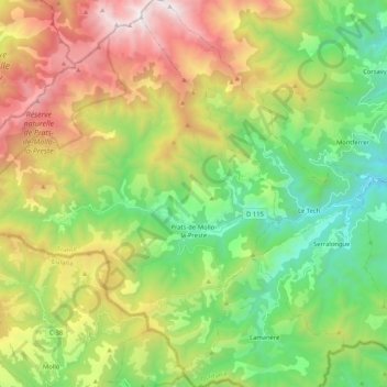
Prats-de-Mollo-la-Preste topographic map
Click on the map to display elevation.
Thank you for supporting this site ❤️
Make a donation
Make a donation
Prats-de-Mollo-la-Preste
Prats-de-Mollo-la-Preste is located in the Pyrenees, 13 km (8.1 mi) from the Spanish border and the Autonomous Community of Catalonia, on the banks of the river Tech, and on the south face of the Canigou at an elevation of 735 meters.
Thank you for supporting this site ❤️
Make a donation
Make a donation
About this map
Name: Prats-de-Mollo-la-Preste topographic map, elevation, terrain.
Average elevation: 1,295 m
Minimum elevation: 416 m
Maximum elevation: 2,721 m
Thank you for supporting this site ❤️
Make a donation
Make a donation
Other topographic maps
Click on a map to view its topography, its elevation and its terrain.
Thank you for supporting this site ❤️
Make a donation
Make a donation
L'Ermitage
France > Occitania > Pyrénées-Orientales > Font-Romeu-Odeillo-Via > L'Ermitage
Average elevation: 1,785 m
Thank you for supporting this site ❤️
Make a donation
Make a donation
Les Escaldes
France > Occitania > Pyrénées-Orientales > Angoustrine-Villeneuve-des-Escaldes
Average elevation: 1,491 m
Thank you for supporting this site ❤️
Make a donation
Make a donation