
Thank you for supporting this site ❤️
Make a donation
Make a donation
Arcueil topographic map
Click on the map to display elevation.
Thank you for supporting this site ❤️
Make a donation
Make a donation
Arcueil
The commune of Arcueil covers an area of 233 ha (0.90 sq mi). Its highest elevation is 105 m (344 ft), its lowest point is 42 m (138 ft).
Thank you for supporting this site ❤️
Make a donation
Make a donation
About this map
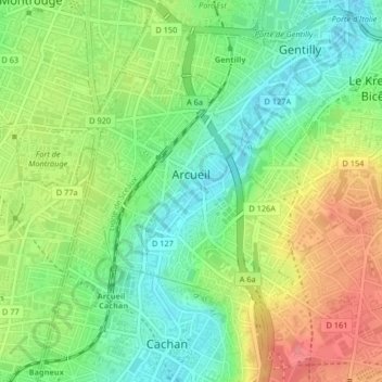
Name: Arcueil topographic map, elevation, terrain.
Average elevation: 78 m
Minimum elevation: 41 m
Maximum elevation: 129 m
Thank you for supporting this site ❤️
Make a donation
Make a donation