
Thank you for supporting this site ❤️
Make a donation
Make a donation
Carregal do Sal topographic map
Click on the map to display elevation.
Thank you for supporting this site ❤️
Make a donation
Make a donation
About this map
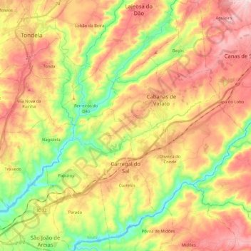
Name: Carregal do Sal topographic map, elevation, terrain.
Location: Carregal do Sal, Viseu, Portugal (40.38058 -8.06853 40.53807 -7.90310)
Average elevation: 272 m
Minimum elevation: 119 m
Maximum elevation: 422 m
Thank you for supporting this site ❤️
Make a donation
Make a donation
Other topographic maps
Click on a map to view its topography, its elevation and its terrain.
Thank you for supporting this site ❤️
Make a donation
Make a donation
Thank you for supporting this site ❤️
Make a donation
Make a donation
Thank you for supporting this site ❤️
Make a donation
Make a donation
Casal de Cima
Portugal > Viseu > Vilar de Besteiros e Mosteiro de Fráguas > Vilar de Besteiros > Casal de Cima
Average elevation: 338 m
Pedreles
Portugal > Viseu > Fornos de Maceira Dão > Fornos de Maceira Dão > Pedreles
Average elevation: 447 m
Thank you for supporting this site ❤️
Make a donation
Make a donation