
Thank you for supporting this site ❤️
Make a donation
Make a donation
Schaumburg topographic map
Click on the map to display elevation.
Thank you for supporting this site ❤️
Make a donation
Make a donation
About this map
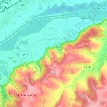
Name: Schaumburg topographic map, elevation, terrain.
Location: Schaumburg, Frauenberg, Landshut, Bavaria, 84036, Germany (48.56046 12.23751 48.60046 12.27751)
Average elevation: 419 m
Minimum elevation: 367 m
Maximum elevation: 496 m
Thank you for supporting this site ❤️
Make a donation
Make a donation