
Zielona Góra topographic map
Interactive map
Click on the map to display elevation.
About this map
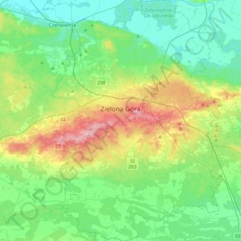
Name: Zielona Góra topographic map, elevation, terrain.
Location: Zielona Góra, Lubusz Voivodeship, Poland (51.82017 15.40595 52.03511 15.65243)
Average elevation: 90 m
Minimum elevation: 41 m
Maximum elevation: 214 m
Other topographic maps
Click on a map to view its topography, its elevation and its terrain.
Wrzesiny
Poland > Lubusz Voivodeship > Żagań County
Wrzesiny, gmina Brzeźnica, Żagań County, Lubusz Voivodeship, 68-113, Poland
Average elevation: 123 m