
Krakow topographic map
Interactive map
Click on the map to display elevation.
About this map
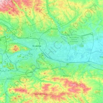
Name: Krakow topographic map, elevation, terrain.
Location: Krakow, Kraków County, Lesser Poland Voivodeship, Poland (49.96767 19.79224 50.12613 20.21735)
Average elevation: 258 m
Minimum elevation: 187 m
Maximum elevation: 457 m
Other topographic maps
Click on a map to view its topography, its elevation and its terrain.
Rabka-Zdrój
Poland > Lesser Poland Voivodeship > Nowy Targ County
Rabka-Zdrój, gmina Rabka-Zdrój, Nowy Targ County, Lesser Poland Voivodeship, 34-700, Poland
Average elevation: 594 m
Krakow
Poland > Lesser Poland Voivodeship
Krakow, Lesser Poland Voivodeship, Poland
Average elevation: 263 m
Krakow
Poland > Lesser Poland Voivodeship > Krakow
Krakow, Lesser Poland Voivodeship, Poland
Average elevation: 263 m
Schronisko PTTK Morskie Oko
Poland > Lesser Poland Voivodeship > Brzegi
Schronisko PTTK Morskie Oko, Droga Oswalda Balzera, Brzegi, gmina Bukowina Tatrzańska, powiat tatrzański, Lesser Poland Voivodeship, 34-500, Poland
Average elevation: 1,680 m