
City of Edinburgh topographic map
Interactive map
Click on the map to display elevation.
About this map
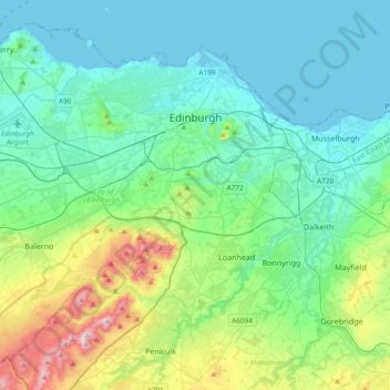
Name: City of Edinburgh topographic map, elevation, terrain.
Location: City of Edinburgh, Scotland, United Kingdom (55.81879 -3.44953 56.00408 -3.07495)
Average elevation: 134 m
Minimum elevation: 0 m
Maximum elevation: 578 m
Edinburgh has been popularly called the Athens of the North since the early 19th century. References to Athens, such as Athens of Britain and Modern Athens, had been made as early as the 1760s. The similarities were seen to be topographical but also intellectual. Edinburgh's Castle Rock reminded returning grand tourists of the Athenian Acropolis, as did aspects of the neoclassical architecture and layout of New Town. Both cities had flatter, fertile agricultural land sloping down to a port several miles away (respectively, Leith and Piraeus). Intellectually, the Scottish Enlightenment, with its humanist and rationalist outlook, was influenced by Ancient Greek philosophy. In 1822, artist Hugh William Williams organized an exhibition that showed his paintings of Athens alongside views of Edinburgh, and the idea of a direct parallel between both cities quickly caught the popular imagination. When plans were drawn up in the early 19th century to architecturally develop Calton Hill, the design of the National Monument directly copied Athens' Parthenon. Tom Stoppard's character Archie of Jumpers said, perhaps playing on Reykjavík meaning "smoky bay", that the "Reykjavík of the South" would be more appropriate.
Other topographic maps
Click on a map to view its topography, its elevation and its terrain.
Tornagrain
United Kingdom > Scotland > Highland
Tornagrain, Highland, Scotland, IV2 8AL, United Kingdom
Average elevation: 51 m
Cawdor
United Kingdom > Scotland > Highland
Cawdor, Highland, Scotland, IV12 5BL, United Kingdom
Average elevation: 77 m
Glencoe
United Kingdom > Scotland > Highland
Glencoe, Highland, Scotland, PH49 4HS, United Kingdom
Average elevation: 114 m
Inveroran
United Kingdom > Scotland > Argyll and Bute
Inveroran, Argyll and Bute, Scotland, PA36 4AQ, United Kingdom
Average elevation: 227 m
Bridge of Orchy
United Kingdom > Scotland > Argyll and Bute
Bridge of Orchy, Argyll and Bute, Scotland, PA36 4AD, United Kingdom
Average elevation: 324 m
Isle of Arran
United Kingdom > Scotland > North Ayrshire
Isle of Arran, North Ayrshire, Scotland, United Kingdom
Average elevation: 98 m
Motherwell
United Kingdom > Scotland > North Lanarkshire > Motherwell
Motherwell, North Lanarkshire, Scotland, ML1, United Kingdom
Average elevation: 82 m
Inverness
United Kingdom > Scotland > Inverness
Inverness, Highland, Scotland, IV1 1PJ, United Kingdom
Average elevation: 163 m
Orkney Islands
United Kingdom > Scotland > Nesstoun
Orkney Islands, Greenspot Road, Nesstoun, Orkney Islands, Scotland, KW17 2BE, United Kingdom
Average elevation: 9 m
Waterhead Farm
United Kingdom > Scotland > Waterhead Farm
Waterhead Farm, North Lanarkshire, Scotland, G67 3HT, United Kingdom
Average elevation: 132 m
Newmains
United Kingdom > Scotland > Newmains
Newmains, North Lanarkshire, Scotland, ML2 9AX, United Kingdom
Average elevation: 163 m
East Kilbride
United Kingdom > Scotland > East Kilbride
East Kilbride, South Lanarkshire, Scotland, United Kingdom
Average elevation: 177 m
Alltsigh
United Kingdom > Scotland > Alltsigh
Alltsigh, Highland, Scotland, IV63 7YD, United Kingdom
Average elevation: 189 m
Millbank
United Kingdom > Scotland > Millbank
Millbank, Aberdeenshire, Scotland, AB51 7RX, United Kingdom
Average elevation: 181 m
Wishaw
United Kingdom > Scotland > Wishaw
Wishaw, North Lanarkshire, Scotland, ML2, United Kingdom
Average elevation: 124 m
Mull
Mull, Argyll and Bute, Scotland, United Kingdom
Average elevation: 122 m
Old Town
United Kingdom > Scotland > Edinburgh
Old Town, Edinburgh, City of Edinburgh, Scotland, United Kingdom
Average elevation: 61 m
North Connel
United Kingdom > Scotland > North Connel
North Connel, Argyll and Bute, Scotland, PA37 1PL, United Kingdom
Average elevation: 19 m
Grampian Mountains
Grampian Mountains, Highland, Scotland, United Kingdom
Average elevation: 775 m
West End
United Kingdom > Scotland > Edinburgh
West End, Edinburgh, City of Edinburgh, Scotland, United Kingdom
Average elevation: 59 m
Aberdeen
United Kingdom > Scotland > Aberdeen
Aberdeen, Aberdeen City, Scotland, AB11 5EQ, United Kingdom
Average elevation: 52 m
Caldervale
United Kingdom > Scotland > Haughhead
Caldervale, Haughhead, South Lanarkshire, Scotland, G71 7RN, United Kingdom
Average elevation: 33 m
Ben Nevis
United Kingdom > Scotland > Highland
Ben Nevis, Highland, Scotland, United Kingdom
Average elevation: 912 m
Waterton
United Kingdom > Scotland > Waterton
Waterton, Aberdeenshire, Scotland, AB41 9QQ, United Kingdom
Average elevation: 32 m
Cairnsmore of Fleet
Cairnsmore of Fleet, Dumfries and Galloway, Scotland, DG8 7BL, United Kingdom
Average elevation: 489 m
Cairngorm Mountains
Cairngorm Mountains, Aberdeenshire, Scotland, United Kingdom
Average elevation: 937 m
Spidean Coire nan Clach (Beinn Eighe)
Spidean Coire nan Clach (Beinn Eighe), Highland, Scotland, United Kingdom
Average elevation: 608 m
Hecla
Hecla, Na h-Eileanan Siar, Scotland, United Kingdom
Average elevation: 50 m
Lewis and Harris
Lewis and Harris, Na h-Eileanan Siar, Scotland, United Kingdom
Average elevation: 28 m
Islay
Islay, Argyll and Bute, Scotland, United Kingdom
Average elevation: 53 m