
Serra de Tramuntana topographic map
Interactive map
Click on the map to display elevation.
About this map
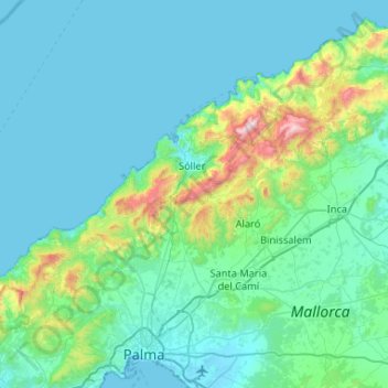
Name: Serra de Tramuntana topographic map, elevation, terrain.
Location: Serra de Tramuntana, Balearic Islands, Spain (39.62579 2.44363 39.84761 2.96694)
Average elevation: 175 m
Minimum elevation: -1 m
Maximum elevation: 1,418 m
The climate in the Tramuntana Range is significantly wetter than the rest of the island, recording as much as 1507 mm (59.3 inches) of precipitation per year, in comparison with some other parts of the island where annual rainfall is less than 400mm (15 inch). It is also cooler due to the altitude, and a few days of snow are not unusual during winter.
Other topographic maps
Click on a map to view its topography, its elevation and its terrain.
Pollença
Spain > Balearic Islands > Serra de Tramuntana
Pollença, Serra de Tramuntana, Balearic Islands, Spain
Average elevation: 115 m