
Thank you for supporting this site ❤️
Make a donation
Make a donation
Gourdon topographic map
Click on the map to display elevation.
Thank you for supporting this site ❤️
Make a donation
Make a donation
About this map
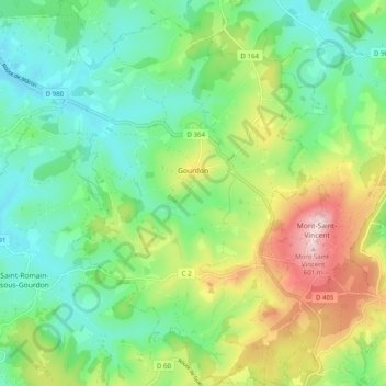
Name: Gourdon topographic map, elevation, terrain.
Average elevation: 398 m
Minimum elevation: 298 m
Maximum elevation: 601 m
Thank you for supporting this site ❤️
Make a donation
Make a donation
Other topographic maps
Click on a map to view its topography, its elevation and its terrain.
La Pommeraye
France > Bourgogne-Franche-Comté > Saône-et-Loire > Beaurepaire-en-Bresse > La Pommeraye
Average elevation: 210 m
Parc d'Activités Les Carrières Rouges
France > Bourgogne-Franche-Comté > Saône-et-Loire > Givry
Average elevation: 239 m
Thank you for supporting this site ❤️
Make a donation
Make a donation