
Make a donation
Paluan topographic map
Click on the map to display elevation.
Make a donation
Paluan
The town is located at the north-western tip of Mindoro Island. It lies along the north-east shore of Paluan Bay, approximately 7 miles southeast of Cape Calavite, a major sea-lane for inter-island and ocean-going vessels. The town is surrounded by rolling and steep mountain ranges, of which Mount Calavite with an altitude of 1,491 metres (4,892 ft) is the highest peak. At Mount Calavite point, the best panoramic view of Occidental Mindoro and nearby islands could be seen.
Make a donation
About this map
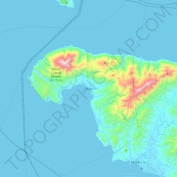
Name: Paluan topographic map, elevation, terrain.
Location: Paluan, Occidental Mindoro, Mimaropa, Philippines (13.18897 120.16005 13.64328 120.61245)
Average elevation: 113 m
Minimum elevation: 0 m
Maximum elevation: 1,490 m
Make a donation
Other topographic maps
Click on a map to view its topography, its elevation and its terrain.
Make a donation
Make a donation
Make a donation
Make a donation
Make a donation
Cabra Island
Philippines > Occidental Mindoro > Lubang
With a length of about 4.5 km (2.8 miles) and about 2.9 km (1.8 miles) at its widest, the island has a flat terrain with the highest elevation at 60.96 metres (around 200 feet). A particular rock islet near one beach is considered by locals as a symbol of the island given its shape as a cabra (Spanish for…
Average elevation: 17 m
Make a donation
Wawa Lighthouse
Philippines > Occidental Mindoro > Abra de Ilog > Lumang Bayan
Average elevation: 26 m
Make a donation
Make a donation
Make a donation
Make a donation
Make a donation